Panoramio Experience (update)
In my last post I lamented that Panoramio and GeoTagger did not *seem* to play together. I was very wrong. GeoTagger does indeed add GPS coordinates to the EXIF jpegs, and Panoramio does indeed read that EXIF info and map the jpegs appropriately. It all works like butter.
Here's where "user error" (my bad) came into play: when I uploaded the GeoTagged images via Panoramio's browser-based uploader, I was impatient. And because I saw the "Map this Photo" button, I incorrectly assumed that it hadn't read the GPS coordinates. Had I clicked "Finish" it would have been automatically read and mapped.
My apologies to both Panoramio and GeoTagger, both of whom have contacted me to help me figure it out (which is very cool, thanks guys!).
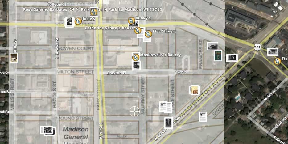
What I'm doing, as part of a Local Games Lab project, is assembling a place-based GeoCultural tour of a Madison, Wisconsin neighborhood that had been decimated by "Urban Renewal" project in the 1960s. This will eventually (this upcoming week) be ported to GPS-enabled Pocket PCs as a walking tour, and ultimately evolve into a game playable by three roles: Urban Planner, Ethnographer, and Historian. For now, I've overlayed a historical map in Google Earth that shows streets and features that have been bulldozed, and I use it to locate images based on other information we have. On Google Earth, it looks like this right now: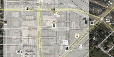 I figure that it would be a good thing to have an option to do a web version of the tour even if you didn't have access to the handheld computers, or weren't in Madison, so combination of Panoramio and GeoTagger seem to be the best and easiest ways to do that. And I'm even more excited that they're cool, dedicated people.
Here's where "user error" (my bad) came into play: when I uploaded the GeoTagged images via Panoramio's browser-based uploader, I was impatient. And because I saw the "Map this Photo" button, I incorrectly assumed that it hadn't read the GPS coordinates. Had I clicked "Finish" it would have been automatically read and mapped.
My apologies to both Panoramio and GeoTagger, both of whom have contacted me to help me figure it out (which is very cool, thanks guys!).
What I'm doing, as part of a Local Games Lab project, is assembling a place-based GeoCultural tour of a Madison, Wisconsin neighborhood that had been decimated by "Urban Renewal" project in the 1960s. This will eventually (this upcoming week) be ported to GPS-enabled Pocket PCs as a walking tour, and ultimately evolve into a game playable by three roles: Urban Planner, Ethnographer, and Historian. For now, I've overlayed a historical map in Google Earth that shows streets and features that have been bulldozed, and I use it to locate images based on other information we have. On Google Earth, it looks like this right now:
 I figure that it would be a good thing to have an option to do a web version of the tour even if you didn't have access to the handheld computers, or weren't in Madison, so combination of Panoramio and GeoTagger seem to be the best and easiest ways to do that. And I'm even more excited that they're cool, dedicated people.
posted by Unknown at 9:32 AM
1 comments
![]()
![]()